
Fail:Mamers Valles, annotated nadir view ESA211664.jpg

A̱tsatsak fail (A̱yaapixel 6,577 × 4,000, shi fail: 7.78 MB, kak MIME: image/jpeg)
Nam-a̱lyiat
| Wa̱i a̱lyiat |
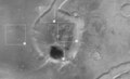
English: The High-Resolution Stereo Camera (HRSC) onboard the ESA spacecraft Mars Express obtained images focusing on a depression that displays a crater at the end of the long, winding valley, Mamers Valles.
The data was obtained on 5 August 2006 with a ground resolution of approximately 14 m/pixel. The image is centred at approximately 39° north and 17° east on the planet. The valley of Mamers Valles is approximately 1000 km long, running along the boundary between the northern lowlands and southern highlands in the region of Deuteronilus Mensae. Scientists term a region such as Mamers Valles ‘fretted terrain’ because it shows numerous deep and wide labyrinth-like valleys and circular depressions which often show structures formed by flowing liquid on their even floors. The structures formed by the flows are thought to be ice-rich debris flows. They show some resemblance to block glaciers seen on Earth. The patches of rock at the centre of the depression are thought to be remnants of rock detached from the flanks of the depression and transported into its centre (2). The wrinkle ridges (3), as the name indicates, are formed by compressive forces acting on the surface. The dark coloured material inside the crater (4) could have formed formed in-situ or was transported by the wind. |
| A̱tuk | |
| A̱tyin | http://www.esa.int/spaceinimages/Images/2008/05/Mamers_Valles_annotated_nadir_view |
| A̱tyulyuut | European Space Agency |
| A̱wat (Á̱ bu shyia̱ di̱ nyia̱ ta̱m ma̱ng fail huni) |
ESA/DLR/FU Berlin (G. Neukum),CC BY-SA 3.0 IGO |
| Other versions |
|
| Title | Mamers Valles, annotated nadir view |
| Mission | Mars Express |
| Activity | Space Science |
Shyiat kwaa̱mbwat a̱ka̱wat
- A byia̱ sa̱t:
- ka̱ a cat ka̱u – ka̱ a cat maat, ka̱u ma̱ng shei ta̱m hu
- ka̱ a cat nyia̱ ri̱mik – ka̱ a cat saai ta̱m hu
- A̱tafa ta̱fwat ji̱ khwi a̱ni:
- a̱di̱dam kaswuo – Ta hwa a nwuak a̱gwai ku myim a̱ni, tyia̱ a̱fwuop kwaa̱mbwat a̱ka̱wat ka, a si̱ wa̱i ka̱ á̱ ku shai kyang mami. A bye nyia̱ a̱nia di̱ kuzang za̱kwa ji̱ myim a̱ni, a̱wot tyong nyian hu si̱sak ji̱ na li á ngyei a̱tyunwuat kwaa̱mbwat a̱ka̱wat wu wa shim ang ku da̱ nggu wa shim nyian ta̱m ang hu a̱ni.
- ka̱u mameang – Ka̱ a nyia̱ ri̱mik, shai, ku a nok tazwa a̱ngga wu, ta hwa a ka̱u jhyet ang ji a̱tafa kwaa̱mbwat a̱ka̱wat ku yet kyang nyiung ku si̱ ku myim a̱ni nang a̱tsak wu.
Nkhang fail
Nyap a̱tuk/jen a nwuan fail hu ma̱nang ku ku ndi di̱ ntsa hu mi̱ di̱n jen a̱ja.
| A̱tuk/Jen | A̱gban ghwughwu | Shi-a̱ka̱ta̱m | A̱tyunta̱m | A̱di̱dam | |
|---|---|---|---|---|---|
| mi̱ di̱ yong huni | 18:16, 24 Zwat Tswuon 2017 | | 6,577 × 4,000 (7.78 MB) | Fæ | European Space Agency, Id 211664, http://www.esa.int/spaceinimages/Images/2008/05/Mamers_Valles_annotated_nadir_view, User:Fæ/Project_list/ESA |
Nyian ta̱m ma̱ng fail
Wat huni nyia̱ ta̱m ma̱ng fail huni: